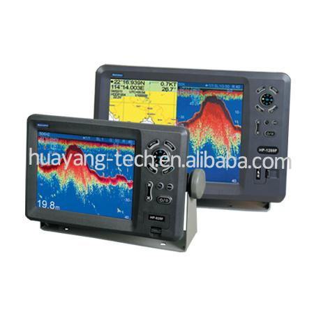
Matsutec
MODEL: KP-628F KP-828F KP-1228F
COLOR LCD GPS Plotter combo with Fish finder
FEATURE:
1 High Resolution
1) KP-628F: 5.6 inches Color TFT Display, 640*640 pixels
2) KP-828F: 8 inches Color TFT Display, 800*600 pixels
3) KP-1228F: 12 inches Color TFT Display, 800*600 pixels
2. 8 Color or 8 Level Amber Presentation
3. 50/200 KHz Transceivers, Output Power:
1) KP-628F 300 Watt
2) KP-828F 600 Watt
3) KP-1228F 600 Watt
4. Blue, Light Blue, or Black Background Color
5. 8 Range Scales, from 0-15 to 0-1000 Feet
1) HP-628F from 0-10m to 0-600m
(Max: 3000ft, 500f, 600pB)
2) HP-828F from 0-10m to 0-1000m
(Max: 3000ft, 500f, 600pB)
3) HP-1228F from 0-10m to 0-1000m
(Max: 3000ft, 500f, 600pB)
6. Range Offset to 0-100 meters
7. Automatic Range and Grain Selection Mode
8. A-Scope Display for Rapid Fish ID and Detection
9. Multiple Display Modes:
-Single or Dual Frequency
-Bottom Zoom
-Bottom Lock Expansion
-Maker Zoom
-Navigation Data Screen
-A-Scope
10. Digital Display of Speed, Depth, Water Temp and Position
11. Adjustable Bottom or Fish Alarm
12. Calibration in Feet, Fathoms or Meters
13. Built-in Picture Simulator
14. SD-cards slot for C-Map and user data
15. C-Map MAX and K-Chart Selectable
16. Tide table and Celestial
17. Versatile Display Mode Include
-Plotter Screen
-Plotter + Sounder
-Sounder
-Nav.Data
-Satellite Information
-AIS Display
-Compass Screen
-Wind Screen
18. GOTO track navigation
19. MAP orientation select
20. Proximity waypoints alarms
21. Perspective View
22. MAP Palette
-Normal
-Daylight – exposed to sunlight
-Night – in dark environment
-NOAA – paper chart colors
SPECIFICATION
PLOTTER CHARACTERISTICS
1. Waypoints/Icons: 14,000 waypoints with name, symbol, 10 proximity waypoint.
2. Route Memory: waypoint up to 169 points each, plus MOB and Track Navigator or Goto Track modes
3. Tracks: 21,000 points automatic track log; 15 saved track (up to 2100 track points each) Let you retrace your path in both directions
4. Alarm: XTE, Anchor Drag, Arrival, Speed, Voltage, Proximity, Waypoint and Time, AIS alarm.
5. Palette
- Normal
- Daylight: Exposed to sunlight
- Night: In dark environment
- NOAA Paper chart color
6. Tides: Tide Data
7. Projection: Mercator projection
8. Position format: Lat/Lon
9. Base Map: Built-in ONWA K-Chart
10. External Map: SD cards slot for user settings
11. User data storage: Internal backup of user settings, or external SD-card
12. Plot Interval: 1s to 99h or 0.01nm to 9.99nm
13. Polotting scales: 0.01nm to 1,000nm
14. Nav Data Input/Output:
- Input:
$--BWC, $--BWR, $--DBT, $--DPT, $--GGA, $--GLL, $--HDG, $--HDM, $--HDT, $--MDA, $--MTW, $--RMA, $--RMB, $--RMC, $--TLL, $--TTM, $--VDR, $--VHW, $--VTG, $--WPL, $--ZDA
- Output:
$--AAM, $--APB, $--BOD, $--BWC, $--GGA, $--GLL, $--RMB, $--RMC, $--VTG, $--XTE, $--ZDA
- Output for autopilot:
$--AAM, $--APB, $--BOD, $--VTG, $--DBT, $--DPT
15. PERSPECTIVE VIEW: On/off
ECHO SOUNDER
- Echo Color
|
8 colors (including background color) according to echo intensity. Monochrome display is also available. The background color is selectable from blue, light blue, white and black.
|
- Basic Range
|
Meters: 10/20/40/80/150/200/300/500/1000
(for HP-628F, up to 600m)
Feet: 30/60/120/200/400/600/1000/1600/3000
( for HP-628F, up to 1500ft)
Fathoms: 5/10/20/40/80/100/150/250/500
(for HP-628F, up to 200fa)
Passi/Braza: 6/20/30/50/100/150/200/300/600
(for HP-628F, up to 300pB)
The basic ranges can be changed on the system menu.
|
- Range Shift
|
Up to 1000 meters (3000 feet, 500 fathoms, 600 passi/braza)
|
- Zoom Range
|
Times 2, 3, 4 and 5 ranges
|
- Bottom Lock Expansion Range
|
5/10meters, 10/20feet, 2/5fathoms, 2/5passi/braza
|
- Auto Mode
|
Automatic adjustment of range and gain
|
- Display Mode
|
High Frequency (200K),Low Frequency (50K), Dual (200K and 50K 1/2display on each), Zoom (200K and 50K zoom) and A-scope Display
|
- Zoom Display
|
Marker Zoom, Bottom Zoom and Bottom-lock Expansion
|
- Display Advance Speed
|
Lines/TX: Freeze, 1/8, 1/4, 1/2, 1/1, 2/1
|
- TX Frequency
- Power Output
|
50 and 200kHz (alternately transmitted)
1)KP-628F: 300W 2)KP-828F/1228F: 600W
|
- Pulse-length/TX rate
- Interface Rejecter
- Alarm
|
Display End Depth(m) 5, 10, 20, 40, 80, 150, 300, 600, 1000
Pulse-Length(ms) 0.15, 0.15, 0.15, 0.25, 0.4, 0.7, 1.5, 1.5, 2.7, 3.6
TX Rate(pulse/min) 750, 750, 750, 375, 187, 107, 50, 50, 30, 21
Rejects unwanted signals by comparing last and present echoes in strength
Fish and Bottom alarms, Temperature alarm (sensor required)
|
GPS Receiver Characteristics
1. Receiver: 50 parallel channel GPS receiver continuously Tracks and uses up to 50 satellites to compute and update your position
2. Acquisition times: Cold start: 27 seconds average
Warm start: 27 seconds average
Hot start: 1 second average
3. Update rate: 1/second, continuous
4. Accuracy: Position: <2.5 meters(95%) without S/A
Velocity: 0.1 meter/sec without S/A
Time: ±100ns synchronized to GPS time
5. Dynamics: Altitude: 50,000m Max
Velocity: 500 m/s
6. Datum: Acceleration: 4g Max
7. Interface: WGS 84 & Others
NMEA 0183 Input, RS232output
8. Antenna: HA-017
AIS interface
Data input: NMEA0183, RS232
Baud rate: 38,400
Power Supply:
1) KP-628F: 10.5 to 35VDC, current drain 1.0A at 12V
2) KP-828F/1228F: 10.5 to 35VDC, current drain 2.5A at 12V
Physical
1. Size:
1) KP-628F: 224mm(H)*151mm(W)*89mm(D)
2) KP-828F: 290mm(H)*195.5mm(W)*99.5mm(D)
3) KP-1228F: 364mm(H)*268mm(W)*106mm(D)
2. Weight:
1) KP-628F: 0.9kg
2) KP-828F: 2.43kg
3) KP-1228F: 3.95kg
3. Display:
1) KP-628F: 5.6 inches Color TFT Display, 640*480 pixels
2) KP-828F: 8.0 inches Color TFT Display, 800*600 pixels
3) KP-1228F: 12.1 inches Color TFT Display, 800*600 pixels
4. Waterproofing: Display unit: IPX5;
Antenna unit: IPX6
3. Temperature range: -15°C to + 55°C (Display unit);
-25°C to + 70°C (Antenna unit)
EQUIPMENT LIST (Standard)
- Display unit
- Antenna unit with 10m cable
- Transducer
- Operator manual
- Installation materials and standard spare parts